
The hike to Gergeti Glacier in Georgia is one of the most beautiful hikes in all of Europe. Tucked away in the Caucasus, these dramatic mountains stretch from the Black Sea to the Caspian Sea along the border of Russia and Georgia/Azerbaijan.
You’d be forgiven for not having heard of these mountains, as these countries are notoriously poor with travel advertising. But these mountains hold all the highest peaks in Europe, towering above the Alps.
In northern Georgia, along the border with Russia lies the 7th highest – and possibly most beautiful – peak in Europe, Mount Kazbegi. Hiking to Gergeti Glacier at the base of the mountain from the valley below is not too difficult but does require a moderate level of fitness as it is very strenuous. This post explains everything you need to know about the hike to Gergeti Glacier, the large glacier at the base of the peak.
Note: this article contains affiliate links, which means that should you purchase something or get a quote through them I may make a small commission at no additional cost to you. This helps keep the site running with up to date information. I do not represent World Nomads, Rentalcars.com, Booking.com or GetYourGuide. This is information only and not a recommendation to buy the product mentioned in this article.
The Gergeti Glacier Hike – What You Need to Know
Where is Mount Kazbegi and Gergeti Glacier?
Mount Kazbegi is on the border of Georgia and Russia. The hike to Gergetit Glacier is fully on the Georgian side. Kazbegi, Georgia is the nearest town and where you’ll base yourself for exploring this amazing region of the world.
How to get to Kazbegi
The nearest airport is Tbilisi, the main airport for Georgia. From Tbilisi it’s about a 3 hour drive to Stepantsminda. You can rent a car, a 4×4, hire a driver to take you there, or take a public minibus (by far the cheapest option).
If you’re driving, be sure to check out my post about driving in Georgia before you go. My recommendation is to rent a 4×4 vehicle and drive to Stepantsminda. It will make getting to the start of this hike much easier.
For booking cars you can use Rentalcars.com as seen in the banner below. Just be sure to book a 4×4 vehicle. Don’t drive around Georgia without one!
It’s also possible to visit Kazbegi on a long day trip from Tbilisi, but you absolutely will not have time to do the Gergeti glacier hike. So if you want to do the hike, you’ll have to stay at least one night in the mountains.
Mount Kazbegi weather
The Caucasus Mountains are notoriously rainy. It is usually nice in the morning and rains in the afternoon. Very rarely is the sky clear all day. Start the hike as early as you can to avoid the afternoon showers. It can get quite cold too, even in peak summer, so you will need to have appropriate cold weather hiking gear.
If you have a window of a few days to do the hike, I suggest following the weather forecast and going on the days that have the best outlook. Mount Kazbegi on a clear day is simply stunning!
Best time of year for the Gergeti Glacier hike
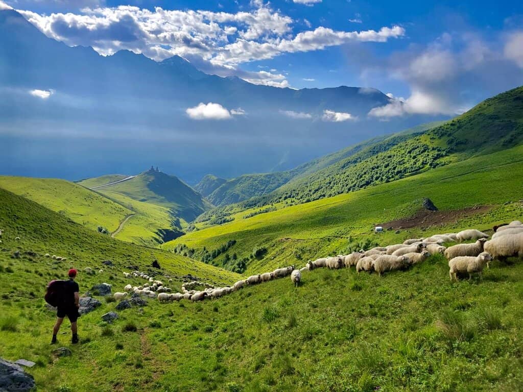
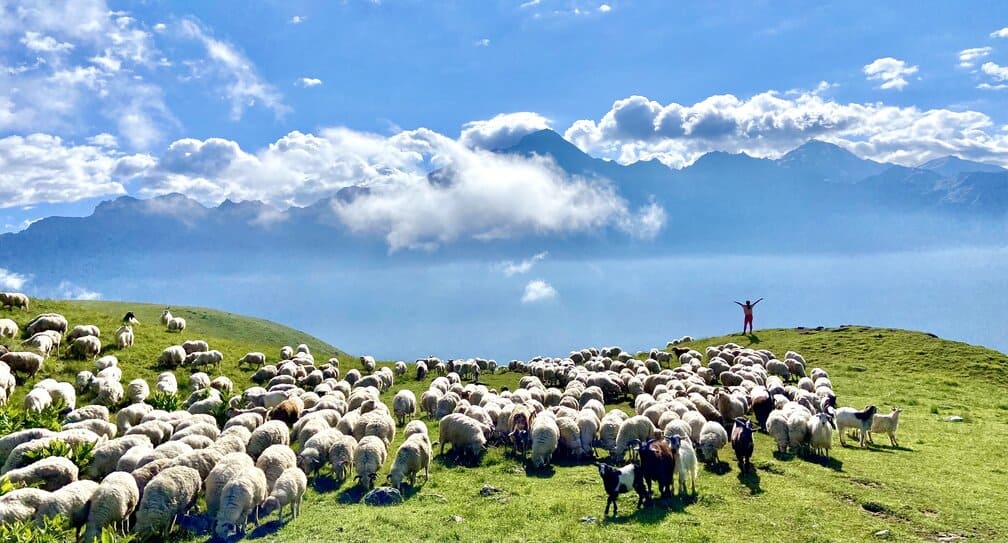
Hiking season for Mount Kazbegi is mid June to September. Though it is possible to hike year round, you’ll be crossing a lot of snow if you go outside the main hiking season. During this window the trail will be clear (not counting the herds of sheep you’ll have to meander through) and the weather will be best.
Where to stay when doing the Gergeti Glacier hike
Most people do the hike as a day trip from Kazbegi (aka Stepantsminda), where there are dozens of affordable guest houses, so it is not necessary to camp or stay in the mountains.
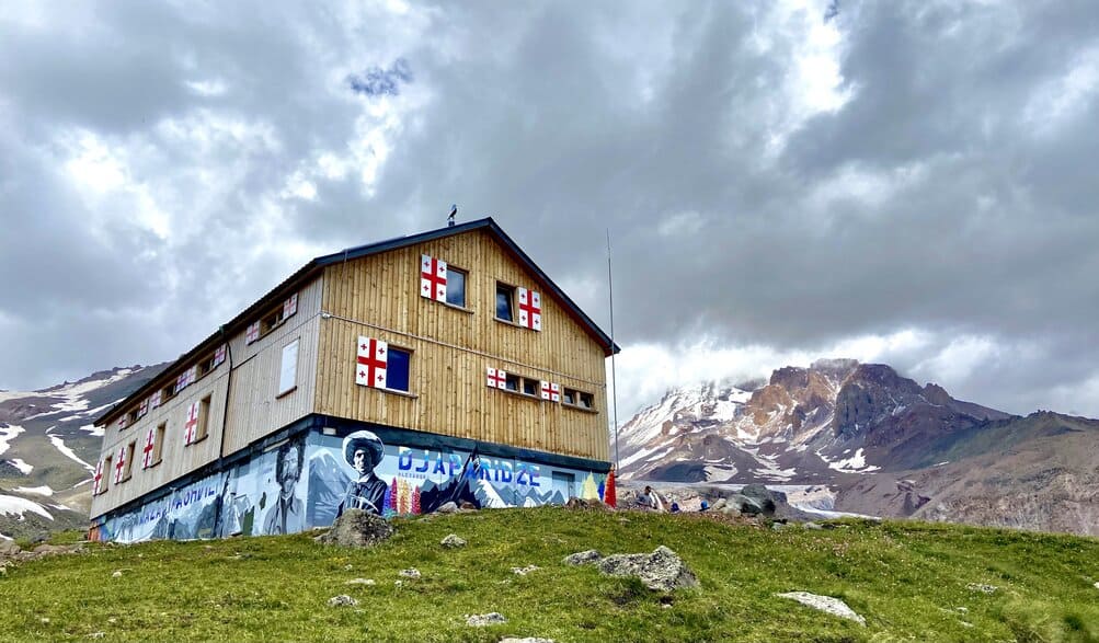
However, if you want to stay high in the mountains you can book a room at the Altihut, right below the glacier. It’s a high mountain hut so the rooms are basic (just bunk beds and blankets), but sufficiently warm. The hut is at 3052 meters (10,010 ft) so it’s quite chilly when the sun is not shining.
It is also possible to pitch a tent anywhere you want along the trail to Gergeti Glacier and freedom camp. Though be warned there are very few flat locations along the trail so if you see somewhere flat you can set up camp don’t let it go to waste.
Where to stay in Kazbegi
Budget: Hotel UP!
Mid-range: Little Wood House
Splurge (still cheap): Elia Loft
Food
There are some small supermarkets in Stepantsminda where you can get some snacks for the hike. The Altihut also has a small kitchen with a few things on the menu so you can stop for a decent meal. But outside of the Altihut you’ll need to bring all your own food on the hike.
Money
The currency in Georgia is the Georgia Lari (GEL). The hike itself is free. Though if you plan on eating at the Altihut that is not free. They accept credit card payments though, so you don’t need to carry any cash for that. But if you need to take a taxi to Gergeti Trinity Church (see THE START OF THE TRAIL section below) you will need some cash for the taxi. In general, it’s always a good idea to have cash on you in Georgia.
Hike length
The total length of the hike to Gergeti Glacier varies depending on where you start and if you want to go past the glacier to the Bethlemi Hut or not. If you start from the Gergeti Church parking lot – as I advise – and hike to the glacier you’ll total about 12 miles (19km) out and back. If you start from town and add the hike up to the church you’ll add about another 3 miles (4.8km) round trip.
Difficulty level
The Gergeti Glacier hike is strenuous. You’ll need a basic level of fitness to complete it without being completely miserable. The first 3 miles are a steep uphill ascent without any flat or downhill relief.
The terrain is not difficult, though, until you get almost to the glacier. In the mile or so before you reach the glacier you’ll have to cross a flowing stream multiple times and the trail is not well marked at all. Just head towards the glacier and keep right.
Elevation
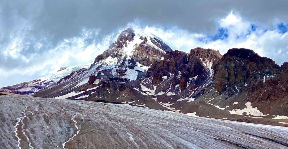
The peak of Mount Kazbegi reaches an elevation of 5052m (16,570 feet). At the foot of the glacier you’ll be at about 3295m (10,810 ft)), so unless you’re summiting the peak you won’t be too high in elevation.
If you’re not used to hiking in the mountains this can be difficult though. Head down immediately if you feel any lightheadedness or other symptoms of altitude sickness.
Popularity
This hike – and Georgia in general – is still pretty wild and undiscovered. Georgia is not yet a popular tourist destination so there are few people to encounter. We saw maybe 30-40 other people in total in our 26 hours on the mountain. You won’t be have to worry about overcrowding on the trail, to say the least.
Travel insurance
Before heading to Georgia, you should consider purchasing travel insurance so that you’re protected for the unexpected. We use World Nomads and have had good experiences with them. World Nomads provides coverage to travelers in over 100 countries. You can search for a coverage plan using the link below.

Gergeti Glacier Hike Preparation
There really isn’t anything you have to do to prepare for the hike to Gergeti Glacier, as it is easily doable in a day. This isn’t the Everest Base Camp trek by any stretch of the imagination. However, be sure to carry clothing for all seasons. You can get warm easily climbing the steep path at the beginning of the trail but also be freezing your butt off by the time you reach the glacier.
Carry waterproof gear and a good rain jacket. You can fill up water at the Altihut by asking the staff nicely. Other than that there is no water in the trail. Don’t drink the stream water without purifying it first. It is not necessary to bring food but you will be burning a lot of calories so it’s good to have some snacks. Most importantly, just prepare for an amazing day in the mountains.
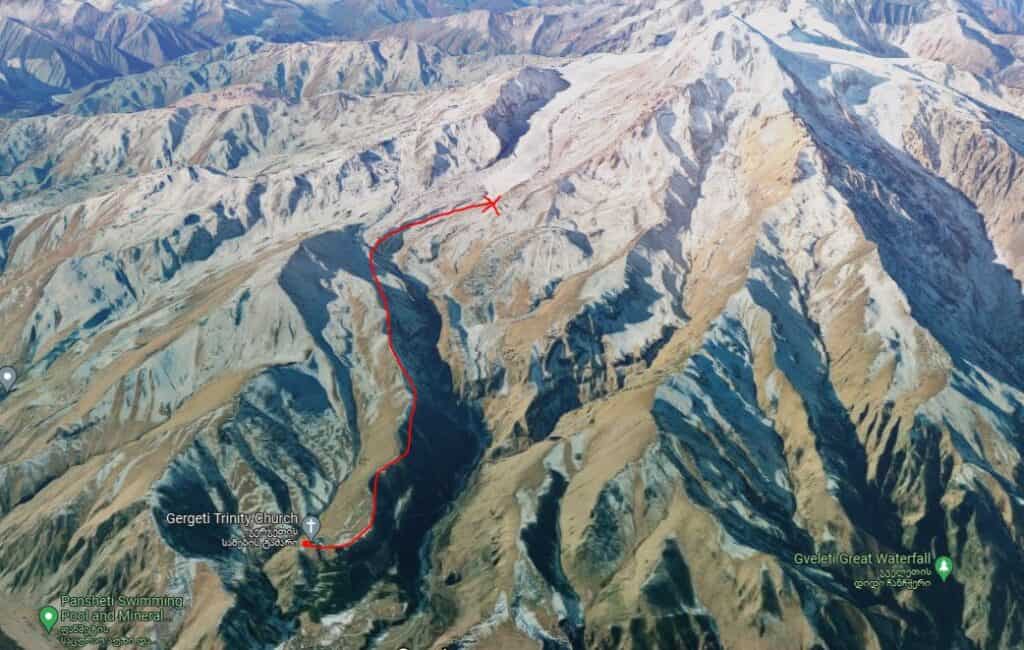
The Start of the Trail
There are two official starting locations for the hike to Gergeti Glacier. You can either start in Stepantsminda or at the Gergeti Trinity Church. Starting at the church will cut about 1.5 miles and 1200 feet of elevation gain off the hike. If you want a serious challenge, start from town. If you’re satisfied with a 3500 foot (1067m) elevation gain though, start at the church.
There is a paved road to Gergeti Trinity Church (see next section). It was damaged by a rockslide in 2020, but as of 2024 the paved road is open, meaning you can avoid the ridiculously bumpy gravel road that requires a 4×4 with high clearance. When we visited we had to take the dirt road and it was a harrowing experience to say the least.
If you don’t have a vehicle, you can take a taxi from the bottom of the hill for 7 GEL each way. These taxis run continuously from about 7:00 – 20:00 and are the main way backpackers get to the church.
We parked our 4×4 in the church parking lot and began the hike from there. Most people we encountered on the trail also started from the church so it seems to be the more popular option. I can’t speak to the trail from town to the church but it looks like many switchbacks straight up the mountain.
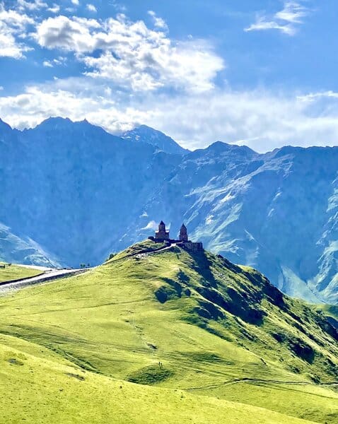
Gergeti Trinity Church
Before starting the hike be sure to check out Gergeti Trinity Church. This is probably the most famous monastery in all of Georgia, thanks to its stunning location in the mountains. If you Google image search “Georgia country” you get photos of this church in the mountains.
Built in the 14th century, it was out of use during Soviet rule, but has since reemerged as an important location for the Georgian Orthodox Church.
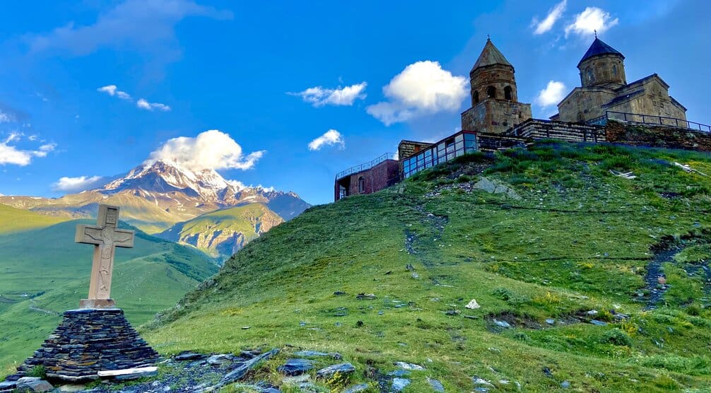
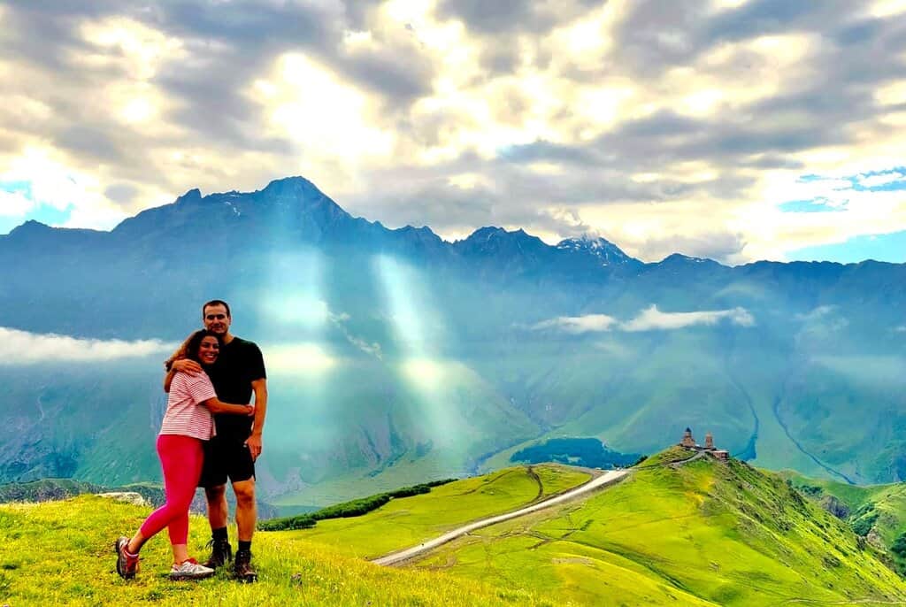
As you hike up you’ll be rewarded with amazing views of the church with jagged granite peaks in the background, but before that head to a little spot (marked by a cross about 4 feet high coming out of the ground) behind the church for a view of the church with Mount Kazbegi.
You’ll also get a great view of Stepantsminda from here. You can enter the church if you are wearing pants (legs must be covered in Georgian monasteries) and pray for a safe hike and good weather.
The Hike to Gergeti Glacier at the Base of Mount Kazbegi
From the parking lot it’s straight up a grassy hillside to start off the hike. There is a dirt road that sort of looks like it might be the trail, but it’s not. That leads to a shepherd’s house so don’t follow that.
The trail starts steep and stays steep. This is not a peaceful walk through the woods. In fact, you won’t pass a single tree, just bushes, flowers, and other alpine plants. This means views in every direction!
The First Half of the Hike
The first half of the hike is by far the more difficult half. The trail is mostly dirt and is also used by cows, horses, and sheep so it will be littered with various types of poop. As you head up, keep looking back towards town. A view of the sun shining on Gergeti Trinity Church with the massive mountains in the background is a sight to behold.
There is no reprise from the steep uphill climb until you reach a pass that overlooks a valley that was once covered by the glacier. At this point you’ve done the majority of the 3500 elevation gain and you will probably be exhausted.
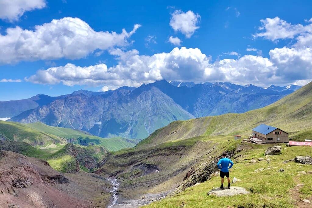
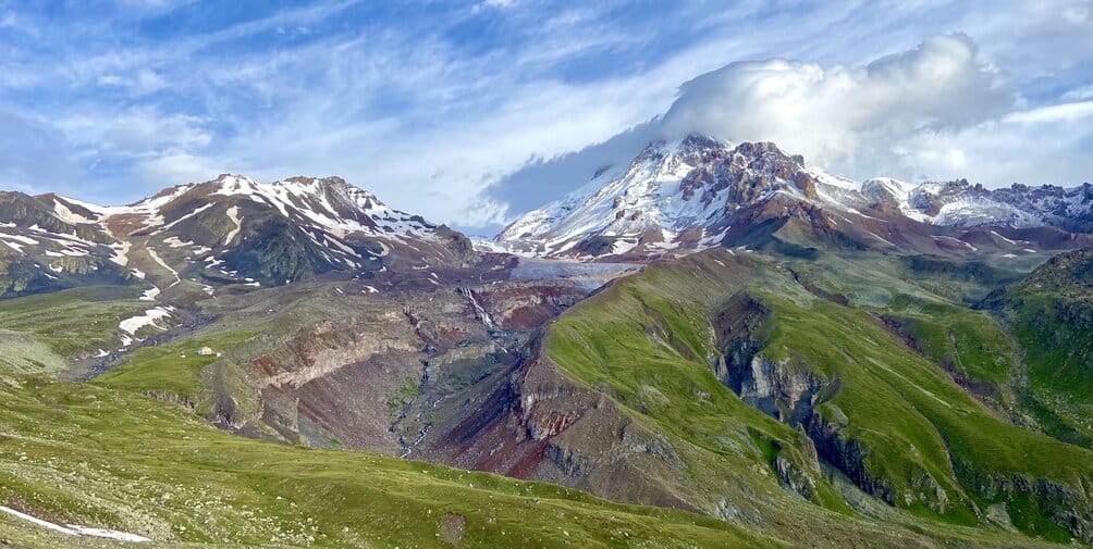
At this pass Mount Kazbegi will come into view again for the first time since the parking lot. You’re a hell of a lot closer to it now though. From here you’ll also see Gergeti Glacier for the first time as well as the Altihut.
The Second Half of the Hike
From the pass your legs will get a slight break as you meander down a shallow incline and stroll along the side of a mountain. But once you cross the stream it’s all uphill again. This time, luckily, the trail is not as steep. Stop for a while to enjoy the views at Altihut before pressing on towards the glacier.
About a half mile past Altihut the terrain changes to more of a loose rock valley. The trail is very difficult to follow here. Stay to the right as much as you can and head towards the three parallel waterfalls. You will have to cross the rapidly flowing stream a few times but should be able to do it without getting your feet wet.
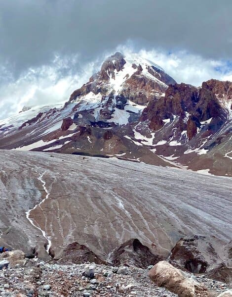
The End of the Trail
Where the trail ends is debatable. We stopped at the foot of Gergeti Glacier and it seemed that most others did the same. But it is also possible to continue over the glacier to another mountain hut called the Bethlemi Hut. This hut is very basic and serves as the base camp for climbers attempting to summit Mount Kazbegi, still another 5000 vertical feet above.
From the church to the foot of the glacier it’s about 6 miles (9.6km) total. There are amazing views the entire way and you will want to stop often to take it all in, as well as to catch your breath. If you’re lucky you’ll get clear skies above Mount Kazbegi.
It’s a conical volcano and rises well above the surrounding peaks. It’s nearly always covered by clouds though. I only got one brief moment where the clouds moved for a second and I can imagine on a clear day it would look stunning above the glacier.
Climbing Mount Kazbegi
According to the locals, it’s possible to climb Mount Kazbegi without any proper technical mountain climbing skills. Only near the very peak is any actual mountain climbing required. It’s mostly just a steep hike.
If you have time it is possible to do it on your own. Though if you’re not an experienced mountain climber it is best to hire a local guide to take you up there. It will be relatively cheap for the security of having a local climber with you.
The peak is about 6500 feet (2000m) above Altihut and about 5000 feet (1525m) above base camp. You will need to spend a night or two at base camp to properly acclimatize before attempting the summit.
Just remember that the peak is usually covered in clouds so don’t expect an amazing view up there unless you get a clear day. On a clear day I can only imagine how beautiful the view from up there would be.
To get to the summit you actually will cross into Russia for a few minutes. Don’t worry though, no visa is needed as long as you stick to the trail. If you’ve made it to the summit let me know how it was!
The Way Down
We stayed overnight at the Altihut and left very early in the morning the next day to get back into town before the rain came. It was a pretty sunny morning and we got some great views of the church on the way back.
We also encountered a herd of sheep (and a few goats) grazing on the mountainside. There are many shepherds that operate in the region so you’ll likely run into some sheep. The hike down is easy and you’ll probably do it in 1/3 of the time it took you to get up.
Just before the parking lot we also ran into a small group of horses. I couldn’t tell if they were wild or domesticated. They were just eating away in the grass. The only other animals you might run into are sheepdogs, who are friendly so long as you don’t fuck with their sheep. There are no bears or deer or anything like that in these mountains.
Geopolitics
As you are aware by now, Mount Kazbegi is shared by Georgia and Russia. Given the current state of affairs with Russia on a global stage you might be wondering if it is safe to travel to northern Georgia and attempt this hike. The locals will assure you that it is in fact very safe, that they are hundreds of miles from Ukraine and not affected by that conflict in any way.
There is a tense history between Russian and Georgia though, so it’s best to be aware of the latest developments in Russian imperialism before you visit Georgia.
In 2008 Russia invaded Georgia and tried to lay claim to some of northern Georgia. Still today there are two breakaway zones of the Caucasus mountains region known as South Ossetia and the Republic of Abkhazia. These are remnants of Russia’s invasion of Georgia in 2008.
These breakaway zones are not official UN recognized countries, but claim their own independence with Russian-backed governments. Under no circumstance should you attempt to enter either of these zones. There are Georgian border guards stationed throughout the mountains on all roads and trails to make sure you don’t accidently enter one of these regions.
Georgia is an amazing, independent country with its own unique culture that will never jive with Russia. But as we know all countries that border Russia, especially non-NATO countries could be at risk in the future.
If there is a day when Russia is talking about invading Georgia again it might be wise to make other plans. But until then northern Georgia is perfectly safe and awaiting your visit!
Gergeti Glacier – FAQs
How do I get to Gergeti Glacier?
There is only one way to get to Gergeti Glacier and that is to hike. You have to hike from Gergeti Trinity Church and it’s quite an intense hike. Luckily this entire article is dedicated to explaining the Gergeti Glacier hike in great detail.
What is the elevation of Gergeti Trinity Church?
The elevation of Gergeti Trinity Church is 2170m (7,118 ft). It might as well be at the valley floor compared to the towering Mount Kazbegi behind it at 5054m (16,581 ft).
Why is Gergeti Trinity Church Famous?
Gergeti Trinity Church is famous for being in an absolutely stunning location deep in the Caucasus Mountains of Georgia. The monastery itself looks similar to other monasteries in Georgia. Beautiful, sure. But its unique setting is what makes it stand out. It’s the first thing that comes up when you Google “Georgia country” and for good reason.
How hard is it to climb Mount Kazbegi?
Climbing Mount Kazbegi is not technically challenging in terms of needing mountain climbing skills. It’s a very steep hike, but it’s possible to do on your own without a guide and without mountain climbing equipment, assuming you are doing it in summer. The peak is always covered with snow, but the locals say anyone willing to brave the wind and the intense uphill climb can do it.
What is the highest mountain in Kazbegi?
The highest mountain in Kazbegi is Mount Kazbegi. At 5054m (16,581 ft) it’s one of the highest peaks in Europe. But it’s not the highest peak in the Caucasus Range. That belongs to Mount Elbrus, also along the Georgia-Russia border. At 5642m (18,510 ft), Elbrus is by far the tallest mountain in Europe.
Final Word
The hike to Gergeti Glacier at the base of Mount Kazbegi is a great experience that will reward you with some of the most amazing alpine views in the world. Add to that the Gergeti Trinity Church and the lack of other humans you will encounter and you have yourself a perfect day in the mountains. Just make sure to get started early so you can enjoy it all before the afternoon rain moves in!