
The Le Morne Brabant hike in southwestern Mauritius is the most iconic and beautiful hike in the small island nation. In this post we will go over the hike in depth and prepare you for one of the most strenuous and steep hikes you will ever do on a tropical island.
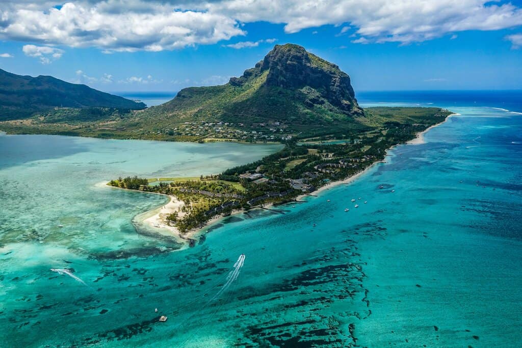
Le Morne is the name of the giant mountain that sticks out of the earth at the very southwestern tip of Mauritius. It’s the most stunning mountain on the island and when you image search “Mauritius” it’s what comes up 90 percent of the time. The peak of the mountain is only 1824 feet above sea level (556m), but don’t be fooled. This mountain is a beast.
It’s an incredibly steep hike that requires significant rock scrambling and even pulling yourself up by a rope in some locations. There’s a 1505 ft (458m) elevation gain (you don’t actually reach the very peak) and most of that is in the last half mile or so. I mean, just look at that photo. What do you think is the best way to get up there?
Now let’s prepare you for the Le Morne hike so you know what to expect!
Note: this article contains affiliate links, which means that should you purchase something or get a quote through them I may make a small commission at no additional cost to you. This helps keep the site running with up to date information. I do not represent Booking.com, GetYourGuide.com, or Discovercars.com. This is information only and not a recommendation to buy the product mentioned in this article.
Le Morne Brabant Hike at a Glance
- Round trip distance: 4.2 miles (6.7 km)
- Difficulty level: Strenuous
- Total elevation gain: 1505 ft (458m)
- Estimated hiking time: 2-3 hours, depending on level of fitness and how long you stay at the top
- Trail starting point: The Le Morne Brabant trail parking lot
- Trail condition: Well marked, easy to follow, and incredibly steep and rocky near the top
- Opening times: year round (last start 2:30 PM due to darkness)
Essentials
How to get there
The only realistic way to do the start of the Le Morne Brabant hike is to drive yourself to the parking lot. Buses and tours don’t stop there and if you took one of the rare taxis on the island you’d have to pay the driver to sit around and wait for you since you’d never get one after the hike. So really, you will need to take your own vehicle.
For renting cars in Mauritius we use Discovercars, as we find they have the best rates. You can book directly using the link below.
Click here to find a great rate on a rental car in Mauritius!
Be sure to also check out my guide to driving in Mauritius before your trip. It’s not a difficult country to drive in, but there sure are a few abnormalities.
There is a parking lot at the base of the mountain after about a mile of the bumpiest dirt road you’ve ever seen. Directions on Google maps are accurate, just be sure to put in this spot, the Le Morne Brabant Hiking parking lot.
Where to stay in southwestern Mauritius
Mauritius is loaded with beautiful resorts on the beach and eco lodges in the mountains. It can be hard to choose where to stay so I’ve given a few options within a 45 minute drive of the Le Morne Brabant parking lot. Though it is possible to drive there if you’re staying on the other side of the island, like if you’re planning on doing the Ile aux Cerfs catamaran tour or something else over there. Just add extra time for getting there and back.
Where to stay in southwest Mauritius
Budget (less than $125 USD per night):
Mid-Range ($125 – 250 USD):
Luxury (more than $250 USD per night):
What to pack
The less you can bring on this hike, the better. Anything you are carrying will just add to the weight you have to pull up the steep rocks. I suggest carrying a small backpack, just enough to bring some water, a snack, and a change of clothes. It’s hot in Mauritius, so you are going to sweat.
Whatever you do, do not bring a large backpacking backpack. This is not the hike you want to carry that thing. So again, just bring the bare minimum. You know how much water you will need to drink so I’m not gonna tell you how much water to bring.
UNESCO World Heritage Site
The Le Morne peninsula of Mauritius is a UNESCO World Heritage Site. The site is actually known as the Le Morne Cultural Landscape, and it gets its World Heritage designation from the mountain being used as a shelter for runaway slaves in the 1700s and 1800s. The escaped slaves used the mountain’s steep cliffs and caves to hide from the plantation owners.
Today Le Morne lives on as a symbol of the slaves’ fight for freedom and their immense suffering. At the base of the mountain on the western side, near the beaches, is the Slave Route Monument, where you can learn a little bit more about the history of slavery in Mauritius.
Travel Insurance
Before you set out on your trip, just make sure to purchase travel insurance so that you’re protected for the unexpected. We use World Nomads and had a good experience the one time we unfortunately had to actually use it. You can search for a coverage plan using the link below.

Hiking Le Morne
Now let’s get into some more detailed information about the Le Morne Brabant hike. You’ll find everything you need to know here. And if you’ve read this far, please do keep reading. I haven’t gotten to the most important part yet!
Where the Le Morne Brabant hike starts
The hike starts from the Le Morne Brabant hike parking lot at the base of the mountain on the southern side. There is a dirt parking lot right on the beach and some information boards at the start of the trail. You can’t miss it.
Length of hike and elevation gain
The total length of the hike is only 4.2 miles (6.7 km) round trip. It’s a nice morning activity that still allows you to enjoy an afternoon on the beach. But don’t be fooled, the last third of the way up to the peak is probably the steepest hike you will ever do.
You’ll gain 1505 feet (458m) over the course of the hike, mostly at the end. If you’re in shape you can count on about 1 hour to get to the top. Going down will actually take about the same amount of time, as you have to be very slow and careful descending the rocky parts at the top.
Either way, the Le Morne Brabant hike is great exercise and will help you work off that fish curry from last night!
Fitness Level and trail difficulty
Here’s where we get into what makes the Le Morne Brabant hike unique. I have done hundreds of hikes all over the world and I’ve never seen anything like this. This trail is as close to rock climbing as you can get without actually rock climbing.
You don’t need to be super fit to do this, but you do need reliable upper body strength and a basic level of fitness. If you consider yourself overweight, I cannot recommend doing this hike. At least not the last third. It’s simply not safe. There is nothing to prove by trying to climb up the rocks at the top. Your safety is more important.
This hike is also not suitable for the elderly or anyone with a physical disability, including ones that affect your arms. You need both hands to safely do this hike. I don’t recommend anyone over 70 do this hike unless you are remarkably agile and fit for your age. I would not allow my mother to do this.
If any of that sounds a bit scary then I recommend you do not do this hike. You need your hands and there are portions where you are going almost straight up. For those able, it’s an amazing experience. But I need to do my part by telling you just how dangerous it can be if your body is not up for it.
You don’t need any sort of special hiking gear, as it won’t help you on the rocks. Sturdy boots are nice, but you’ll be fine with good shoes too. If it has rained recently I would not attempt the hike, as the rocks will simply be too slippery.
General Trail Description
Let’s break the trail up into two parts: the first two thirds and the last third. These parts of the trail are totally different in every way.
The first two thirds of the trail is well marked and leisurely. It’s partly on a paved trail that looks like a 4×4 road and partly on a dirt trail. You’ll gain some elevation, and it is a constant uphill, but anyone can do this part. I saw some older folks on this part of the trail that clearly didn’t attempt the last third, as I never saw them again. There is plenty of shade for when you want to stop and rest as well.
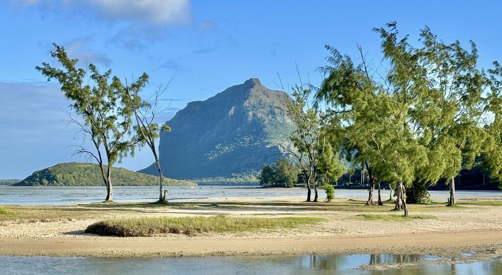
After the nice and easy part of the trail you arrive at sort of a clearing where you can see both coasts of the island and the sprawling Black River Gorges National Park. You look at the dirt trail ahead of you and see the giant Le Morne mountain. At this point it’s hard to see how you can possibly get to the top. This is where it gets fun.
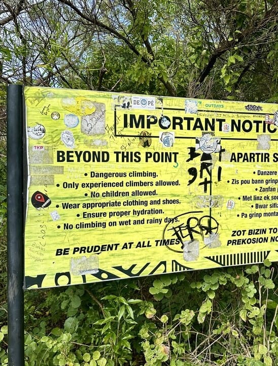
Here you’ll see the sign in the photo below that warns that dangerous climbing is ahead. I usually take these signs with a grain of salt, but this sign is legit. After a bit of walking through some brush on a narrow dirt trail you find yourself staring face to face with a giant, jagged rock. This is the trail.
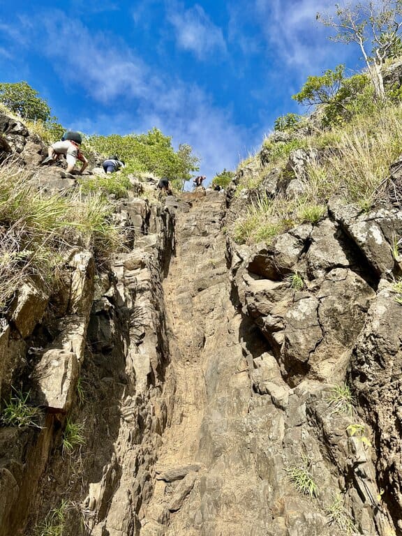
You will see people going up and down. Well, unless you’re literally the first one there on that day. They are using their hands and at this point you realize just what lies ahead of you.
I can only describe the last third of the Le Morne Brabant hike as climbing straight up a rock that is incredibly steep but just shallow enough to allow anyone in good physical condition to do it safely. I think I can best paint the picture for you by showing you the photos below. Look at the sheer terror in that girl’s eyes as she heads down (photo above)!
Use both hands, getting a sturdy grip on the rocks, and you’ll be fine. This rock scrambling continues basically nonstop until you reach the top. You’ll be pretty tired at that point. It’s impossible not to be. Take a rest. You’ve earned it.
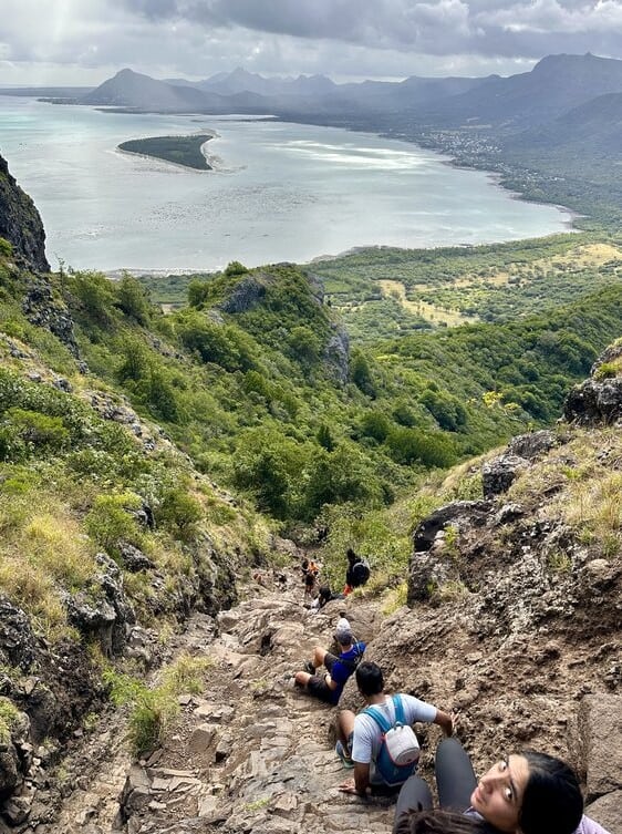
Going down is harder than going up. Be prepared to wait as people descend safely one at a time. While easier on the lungs, the terrain is more challenging to go down. There are many points where you’ll have to go down backwards, as it’s just safer. Rely on others for help if needed.
In general, the trail is easy to follow. Even the last third up the rocks is clear to follow, even if it’s not marked. There is really only one way up, so you can’t get lost.
Views along the way
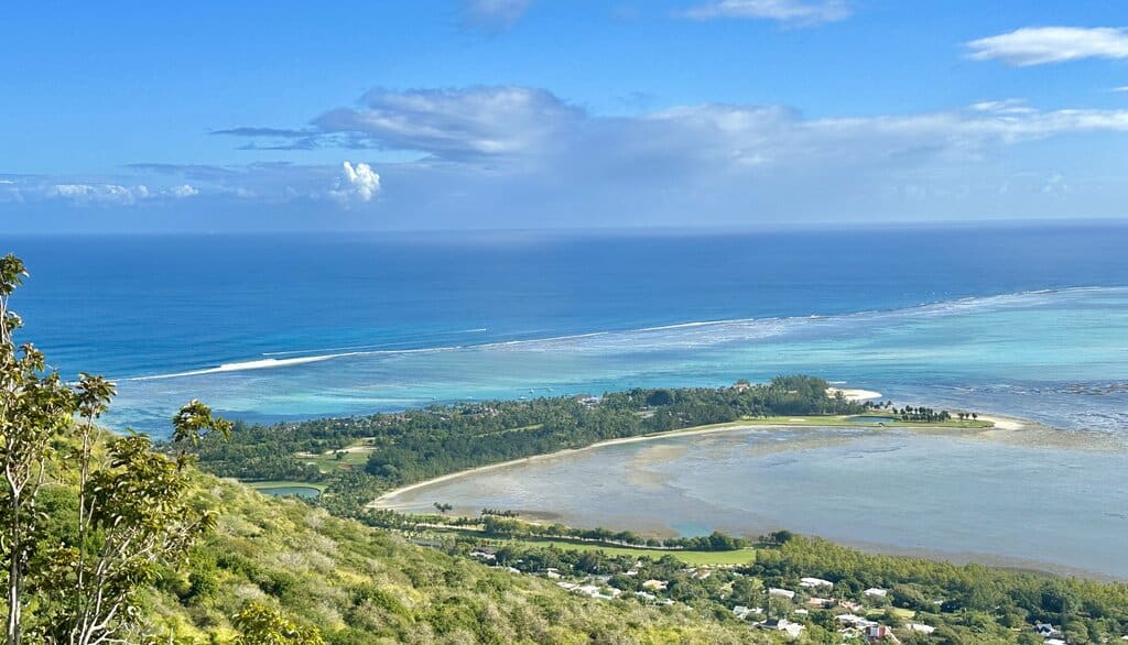
While the first two thirds of the hike are forested, the final third is mostly treeless and open. Once you get to the clearing before heading up the steep rocks you get a lovely view of the island looking north and east. This view east is as seen in the photo below. You can see the beautiful beaches below as well as the golf resorts.
As you head up the steep rocks you’ll also get plenty of chances to stop and enjoy some nice views.
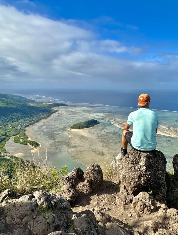
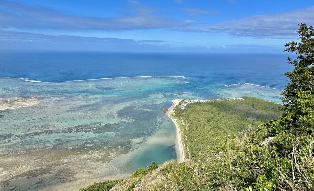
The view at the top
Spoiler alert: the end of the hike is not at the peak of Le Morne. It’s not possible to reach the actual summit as it’s a sheer rock wall that is too dangerous to climb. So the hike’s “summit” is actually marked a little lower than the actual peak, meaning there is not a 360-degree view.
From the top you can see south and east. Straight down you’ll see some fancy resorts on the beach and to the east you’ll see the rugged southern coastline. To be honest I think the view from the lower clearing is better, but it’s still pretty damn nice up there.
There is not a whole lot of space at the top so you might find yourself up close and personal with other hikers. Enjoy the view before heading back, as going down the rocks is quite intense.
Hiking Le Morne Brabant with children
Children are strictly prohibited from doing the final third of the Le Morne Brabant hike (the point where the steep rocks start). So if you are hiking with kids, either walking themselves or carrying them, you simply won’t be able to make it to the top.
The question then becomes: what age is no longer considered a “child.” Clearly a healthy 15-year old would be fine. In fact, there was a large group of middle school or high school students who looked maybe 13-14 years old doing the hike with me and they were booking it. They were in far better shape than the average hiker.
I’d say teenagers are fine, or maybe a 12-year old if they’re tall and fit. But small children are an absolute no-no. In the end, it’s your discretion if your child is big enough and capable enough to do this hike.
Typical weather for the hike
I will stress right now that this hike cannot be done in rain or immediately after rain on the mountain. This is due to the rocks becoming too slippery when wet. You’ll need to pay close attention to the weather forecast before setting out on the hike. If you get stuck in rain, you really should not do the rock scrambling final part of the hike.
It does rain a lot in Mauritius, especially in the mountains, so overnight rain is not uncommon. In that case, I’d allow at least a few hours of sun to dry the mountain before you try to ascend the rocks. In the end it’s up to you to make a smart decision whether or not the rocky path is safe enough when you get there.
In terms of temperature, it’s usually pretty hot and humid in Mauritius, though winter mornings can be pretty pleasant and even downright cool. The earlier in the morning you can do the better, as by the midday sun it’s usually pretty hot.
Guided hikes
Going on a guided hike to Le Morne Brabant is actually quite common. I saw numerous tour groups doing the hike, mostly guided in French, though there are English options too. If what I’ve described so far sounds exhilarating but also a little scary and you’d feel more comfortable with an experienced guide, then there are numerous tour operators that offer guided Le Morne Brabant hikes.
The guided hike is the same thing I’ve described in this post, you just get to go with a group and a local mountaineer. You’ll also get information about the island and the geology of the area if you go with a guide.
Click here to book a guided Le Morne Brabant tour!
The Le Morne Beaches
What’s the best thing to do after a strenuous hike up a beastly mountain? Depends who you ask, of course, but I’m sure many would say taking a nice dip in the sea. Luckily for you, you’re in Mauritius!
On the west side of Le Morne is a long stretch of sand flanked by beautiful palm trees. Le Morne Beach is arguably the nicest beach in Mauritius. It sits on a fabulous part of the lagoon that surrounds the island that gives it clear, shallow, and incredibly calm water. It’s essentially what people think of when they imagine a picture-perfect tropical beach.
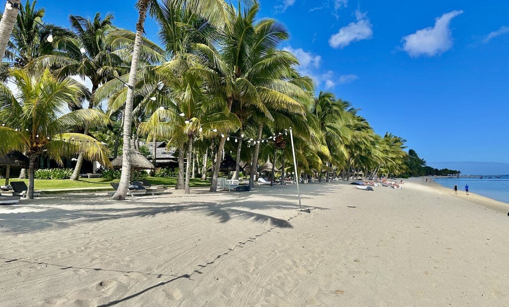
There are a few 5-star resorts along this stretch of beach, including the St. Regis, LUX Le Morne, Dinarobin Beachcomber Golf Resort & Spa, and Paradis Beachcomber Golf Resort & Spa. But if you’re not staying at one of these expensive beach resorts all hope is not lost. Between LUX and Dinarobin is a long stretch of public beach. Parking is free. There is a toilet and a few food stands. But most importantly there is Le Morne Beach.
If you’re not at one of the resorts you’ll have to bring your own towels and everything you need to go to the beach. But damn if that water doesn’t feel nice after a long hike!
Final Word
The Le Morne Brabant hike in Mauritius is a fun, but strenuous and steep hike up the most beautiful mountain in the country. It will test your physical abilities, but you’ll be rewarded with amazing views and newfound confidence.
Just remember that the hike is not for everyone and can be dangerous if you attempt it without proper fitness or physical capabilities. If there is one thing you take from this post I hope it’s that it’s an amazing hike but not suitable for everyone.