
The Lofoten Islands in northern Norway are one of the most photogenic places in the world. You’ve surely seen the photos before. A steep, sharp mountain peak coming straight out of the sea. An aerial view of a lone soccer field. A fisherman’s boat docked in front of a colorful, old house.
These are just some of the many famous shots on the islands, though there are many more. In this article we will go over the best and most Instagrammable places in the Lofoten Islands.
- Lofoten Islands Basics
- The Most Instagrammable Places in the Lofoten Islands
- 1) Bridge to Hamnoy
- 2) The Top of Reinebringen Mountain
- 3) Reine Viewpoint
- 4) The Lone Yellow Rorbu, Reine
- 5) The E10 Bridge Near Anita’s Seafood (looking the other way)
- 6) The Pier in Henningsvaer
- 7) Henningsvaer Stadium
- 8) The Land Bridge on the Way to Henningsvaer
- 9) Stockfish Racks at Henningsvaer
- 10) Nusfjord
- 11) The Road to Nusfjord
- 12) The Mannen Peak at Haukland Beach
- 13) Ryten Peak at Kvalvika Beach
- 14) Rambergstrands (Ramberg Beach)
- 15) The Bridge to Ballstad
- 16) The Stockfish Racks at Lofoten Seafood Center
- 17) Statles Rorbusenter, Mortsund
- 18) Gimsoy Kirke, Gimsoy
- 19) The E10, near Morpheus Beach
- Lofoten Islands Photo Ops – FAQs
- Final Word
Note: this article contains affiliate links, which means that should you purchase something or get a quote through them I may make a small commission at no additional cost to you. This helps keep the site running with up to date information. I do not represent World Nomads, Booking.com, Manawa, Rentalcars.com, or Discovercars.com. This is information only and not a recommendation to buy the product mentioned in this article.
Lofoten Islands Basics
First, let’s start with a quick intro to the Lofoten Islands. You can skip ahead by using the shortcuts in the Table of Contents above.
Where are the Lofoten Islands?
The Lofoten Islands are in Northern Norway, just north of the Arctic Circle on the North Atlantic coast. The chain of five islands is rugged and raw, a true hiker’s paradise.
They are connected to mainland Norway by a series of bridges and tunnels, making them remarkably easy to get to. They stretch about 180 km along the E10 highway to the village of A.
The largest city is Svolvaer, home to about 4700 people. Leknes, the second biggest town, has about 3500 people. The rest of the 25,000 or so people who live in Lofoten are spread across various small villages.
The nearest major city is Tromso, about 380 km north of Hanoy, where the Lofoten Islands begin. Oslo is even further, close to a 20-hour drive. Norway is a long and thin country and traveling south to north takes quite a while by car!
How to get to the Lofoten Islands
The Lofoten Islands are actually not too difficult to get to, thanks to being pretty well connected by regional airports. Most people fly into Harstad/Narvik airport or Bodo airport and rent a car from there.
For more information about getting there, check out my detailed guide on how to get to the Lofoten Islands.
For booking rental cars in Europe we usually use Discovercars.com. They nearly always have the best rates. However, they unfortunately don’t have any agreements with any of the rental companies in the Lofoten Islands. So up in Lofoten we use Rentalcars.com. You can search for a rental car from Harstad/Narvik Airport or one of the other regional airports using the search bar below.
Weather in the Lofoten Islands
The weather in the Lofoten Islands is not great. It’s cloudy most of the time, and these clouds are often low, obstructing your view of the mountains.
But this shouldn’t get you down. Look at all the photos on this page. They are all in overcast skies, but beautiful nonetheless. If the weather is particularly bad one day it can make it difficult to get great photos, so you’ll have to be patient.
In terms of temperatures, the islands have a temperate Arctic climate. This means that the daily high and the daily low temperatures don’t vary much, typically only 2-3 degrees Celsius. It doesn’t ever get hot, and it never gets too cold, with the average low in January being about -1 (30 F).
The issue in Lofoten is really the rain and cloudiness. Refer to my top Lofoten Islands travel tips article for a lot of detailed information on the weather in Lofoten.
What is a rorbu?
A rorbu – short for “rorbuer” – is a traditional Lofoten fisherman’s cabin. The fishermen used to live in these rustic cabins on the water while they fished for cod and other Arctic fish.
These days rorbus have been turned into cozy accommodations for visitors. Most feature a kitchen and at least one separate bedroom. If you’re visiting the Lofoten Islands, be sure to spend at least one night in a rorbu. And if you can, spend all of them!
You’ll see the term “rorbu” used throughout this article, so now you know what it means!
Lofoten adventures and expeditions
The Lofoten Islands are a paradise for adventure seekers and enthusiasts. It’s highly encouraged to do at least one excursion on your trip to Lofoten. Whether it’s a fjord cruise, a fishing expedition, or midnight kayaking, there is something for everyone in Lofoten and all these adventures can be booked on Manawa. Manawa is northern Europe’s leading adventure and tour booking company. Some of the best selling experiences in Lofoten are shown below!
- Summer Kayaking Excursion in Lofoten from Eggum
- Arctic Sailing Excursion to Trollfjord in Lofoten from Svolvær
- Fjord Cruise to Trollfjord in Lofoten from Svolvær
- Trollfjord Sea Eagle Cruise in Lofoten from Svolvær
- Sailing, Hiking, and Fishing Excursion to Skrova in Lofoten from Svolvær
The Most Instagrammable Places in the Lofoten Islands
Now let’s get into what you came here for: the most Instagrammable places in the Lofoten Islands. Most of the photos shared on this page are in vertical format, to be Instagram-friendly, but some photos are best taken in landscape mode.
The places below are in no particular order. You can use the Google Map below to see each exact location so you can be sure to save them in your Google account for your trip.
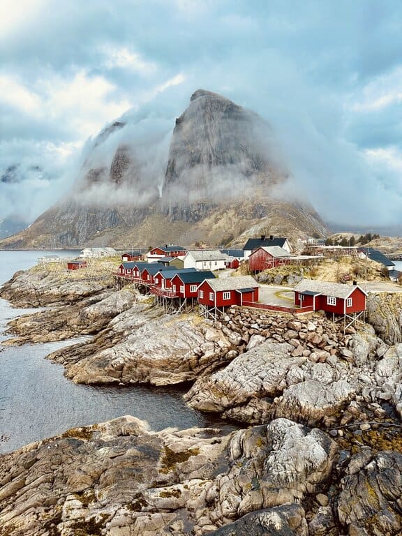
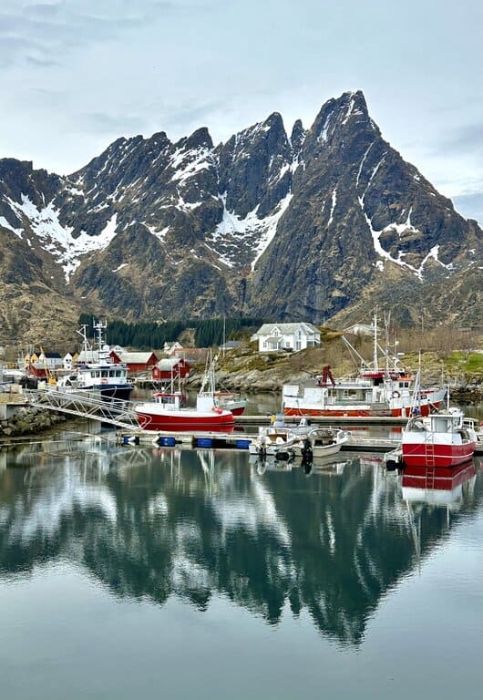
1) Bridge to Hamnoy
For the most classic view of Lofoten rorbus, head to the bridge to Hamnoy. This bridge connects two little islands just north of Reine at the tiny fishing village of Hamnoy.
The best angle for photos is from the eastern half of the bridge. There is a partial sidewalk that you will have to stay on to avoid being hit by a car. It’s a one-way bridge with a stoplight system, so it’s a narrow bridge. Experiment with a few positions along the bridge to get your preferred angle.
For parking, there are areas to pull over on both east and west sides of the bridge. You’ll want to stop on the east side, as the sidewalk does not run continuously to the west side. There is no official parking, but there is a dirt area south of the highway you can stop at.
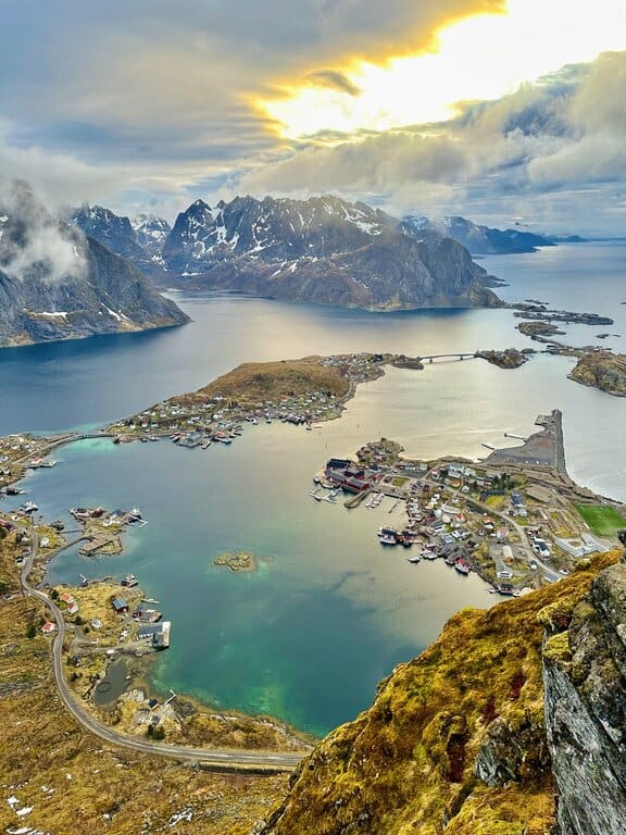
2) The Top of Reinebringen Mountain
The most epic scenic view in all of Lofoten is from the top of the Reinebringen mountain in Reine. The mountain peak gives you a panoramic view of Moskenes Island. Peaks rise from the water in every direction. It can only be described as one of the most beautiful views in the entire world.
To get the view, however, you’ll have to climb the Reinebringen mountain trail. While not technically challenging, the hike involves climbing straight up nearly 1600 stairs. There is literally not a flat moment on the hike. It’s barely a mile, but it’s straight up.
The stairs start from the side of the A10 highway. They were built in 2018 by Nepalese Sherpas. They are solid stone steps and they are in great condition.
You’ll have to walk along the side of the E10 highway before starting the steps, as the nearest parking area is in Reine. It only adds about 10 minutes to the walk if you get a parking spot at the Reine Viewpoint parking lot (see embedded map above). This holds only about 12 cars, though, so in summer you likely won’t get a spot here.
If you don’t get a spot at Reine Viewpoint you’ll have to park in the town. There is a large, paved parking lot in Reine that has room for plenty of cars. It adds another 10-15 minutes onto the walk.
3) Reine Viewpoint
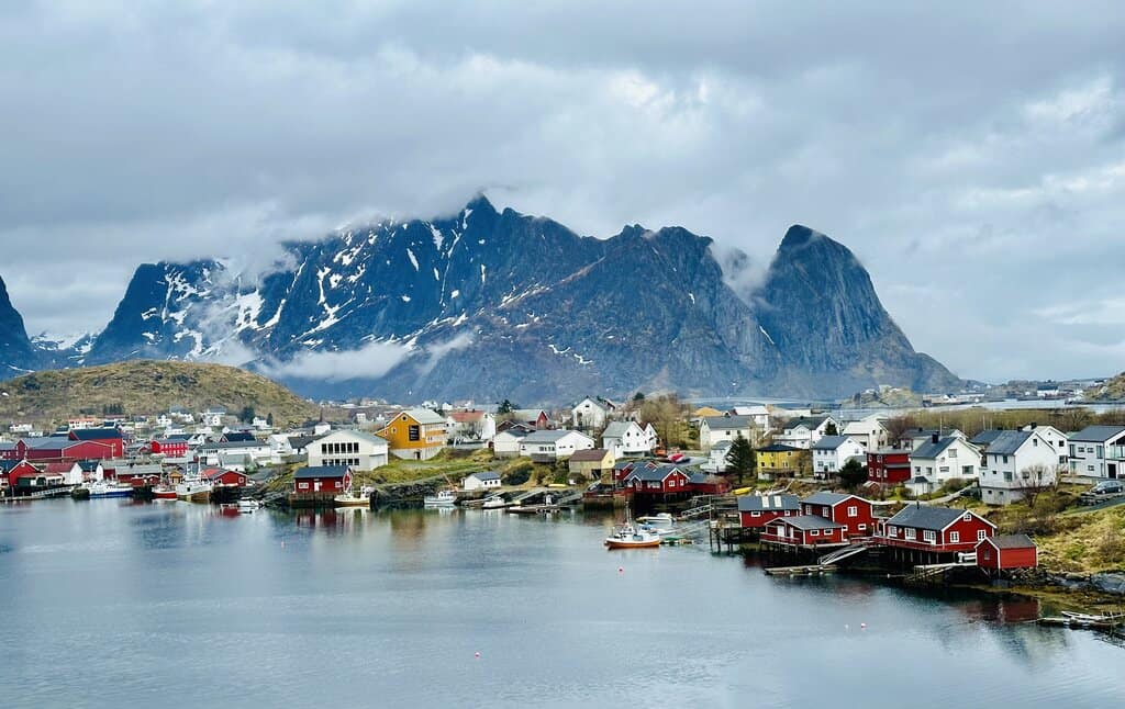
From the Reine Viewpoint parking lot we discussed in the previous section, you can get a classic view of Reine. Reine is considered the most picturesque of the Lofoten fishing villages and it’s the most popular tourist destination on the islands.
From the parking area, walk a little towards the village and you’ll see the scene in the photo below. Not a whole lot of effort is needed to get to this viewpoint, so it’s something you should do at least once.
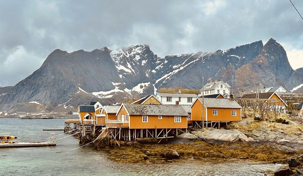
4) The Lone Yellow Rorbu, Reine
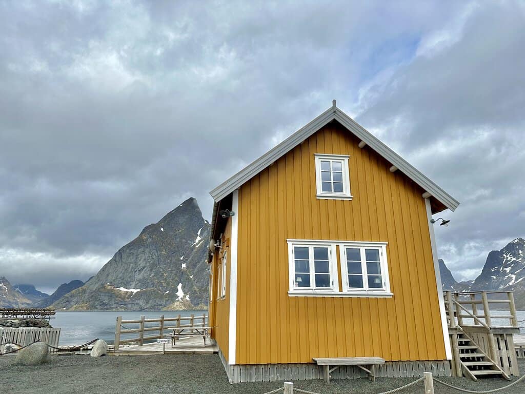
Right by the bridge to Hamnoy there is another beautiful spot for photos (well, two actually, see the next point as well). There is a famous seafood cafe called Anita’s Seafood that’s in a cozy, yellow building.
Right next to the cafe is a lone yellow rorbu with a striking triangular peak behind it. The lone yellow rorbu is the subject of many paintings and photographs of the Lofoten Islands.
To get the view simply park at Anita’s and walk over to the rorbu. Note that you have to go quite a ways back to get the right angle, and in summer you might get some cars and other unsavory features in your photo. The lone yellow rorbu is best photographed in winter, covered in a layer of perfectly white snow.
5) The E10 Bridge Near Anita’s Seafood (looking the other way)
From the exact same spot discussed above for the line yellow rorbu, turn around 180 degrees and you’ll see the equally stunning Sakrisoy Rorbuer. The little yellow rorbus are built atop the rocky shore. In the background you’ll see the Reinebringen peak as well Reine in the distance.
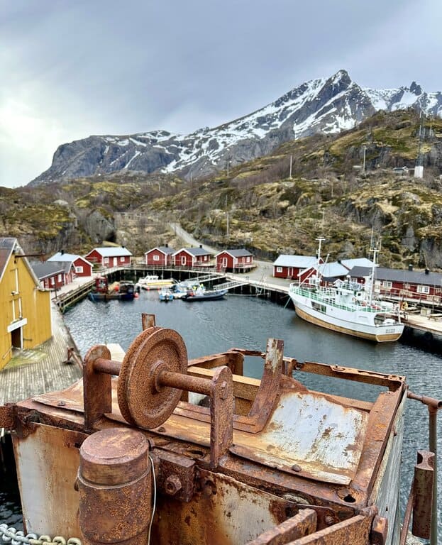
6) The Pier in Henningsvaer
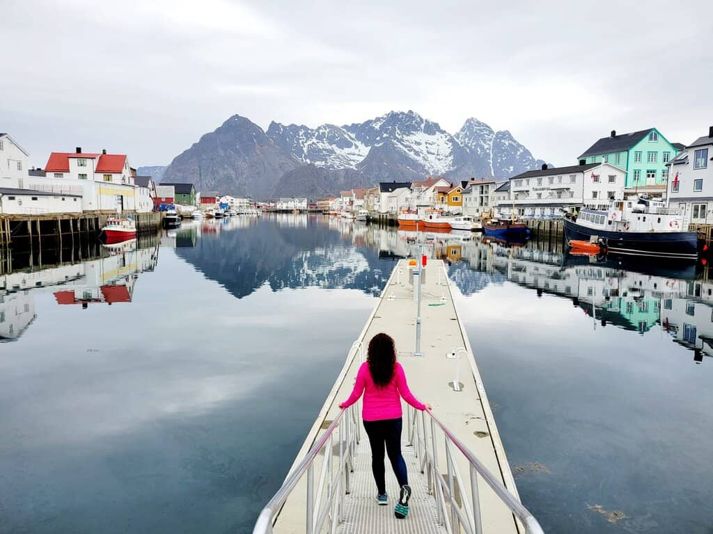
Henningsvaer is another picturesque Lofoten fishing village with numerous amazing photo op locations. Perhaps the best is from the little pier in the middle of the main waterway that splits the town in two. From here you look back towards Festvagtinden peak and the other mountains that rise above Henningsvaer.
This location is particularly photogenic thanks to the colorful buildings and the mountains reflecting on the water when the winds are calm. To get there, simply park on the side of the road wherever you see space. If you don’t see anything good, you can always park at Henningsvaer Stadium and walk a few minutes to the pier.
7) Henningsvaer Stadium
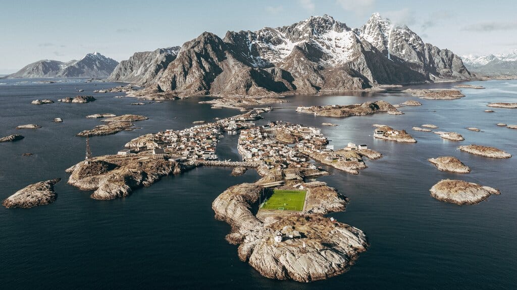
Speaking of Henningsvaer Stadium, one of the most legendary photos in all of Norway can be taken from high above the soccer field in Henningsvaer. There’s just one catch: you’ll need a drone.
The Henningsvaer Stadium is not really a stadium, but just a field. And this soccer field is arguably the most scenic pitch in the world.
Unfortunately, you can’t get a good angle of the field and the mountains in the distance without being high up in the air. There is a little hill behind the stadium, but your view won’t be great from there. So if you don’t have a drone you can skip this one.
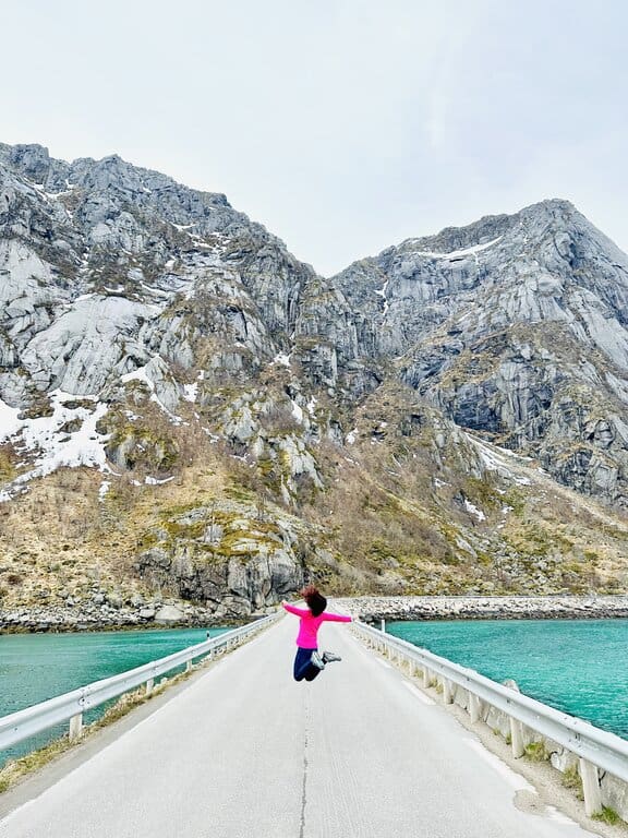
8) The Land Bridge on the Way to Henningsvaer
On the road to Henningsvaer you’ll pass a narrow land bridge that separates the sea from a little inlet. The water is a stunning shade of turquoise and the mountains are as steep as a sheer cliff.
From the middle of the road you can take some pretty epic photos. There is a little place to pull over before you reach the lane bridge, maybe enough room for three cars. Just keep your ears on cue, because it’s a blind corner so you won’t see cars coming but you’ll hear them. Needless to say, get the hell off the road if a car is coming!
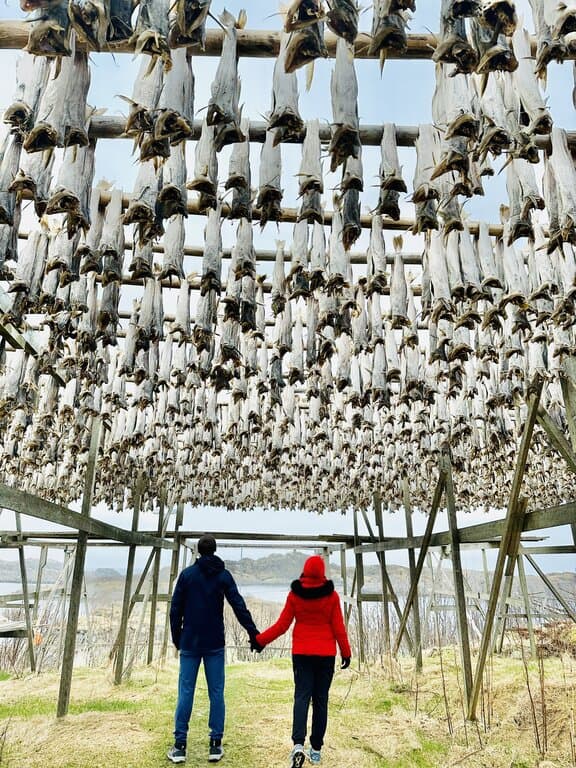
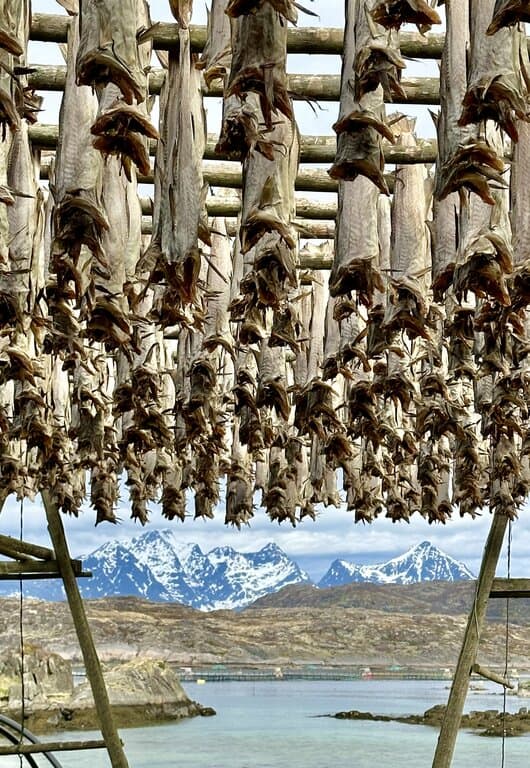
9) Stockfish Racks at Henningsvaer
Let’s first explain what a stockfish rack is. Stockfish is dried cod that is naturally dehydrated out in the open along the shores all across the Lofoten Islands. The fish are hung from wooden structures every winter and left to dry for about three months.
The unique Arctic climate of Lofoten preserves the fish. It never gets too much above or below freezing, which allows the fish to dry and preserve without salt. It’s not an overstatement to say that racks of hanging stockfish are literally everywhere in the Lofoten Islands.
There are hundreds of places to photograph these stockfish, but just outside of Henningsvaer Stadium might have the biggest concentration of them. Here the fish hang high on the racks and you can walk underneath them. Just don’t touch them, because eww.
Lastly, do note that stockfish are dried over the course of about three months starting in the winter. The last remaining racks are cleared by June. So if you’re visiting in summer or fall, you will not see any hanging fish.
10) Nusfjord
One of the most Instagrammable places in the Lofoten Islands is without a doubt the idealistic fishing village of Nusfjord. Tucked away on a back road not far from the town of Leknes, you’ll find this adorable, historic village.
These days Nusfjord is not much more than a couple rorbus and some cafes, but in its heyday it was a busy center of cod fishing. The historic wooden structures remain and provide a stunning scene for walking along the water.
There are a few parking lots at Nusfjord and from there walking around the villages only takes a few minutes. There’s no one particular place that’s more beautiful than the others. It’s really all super charming so just walk around and photograph away!
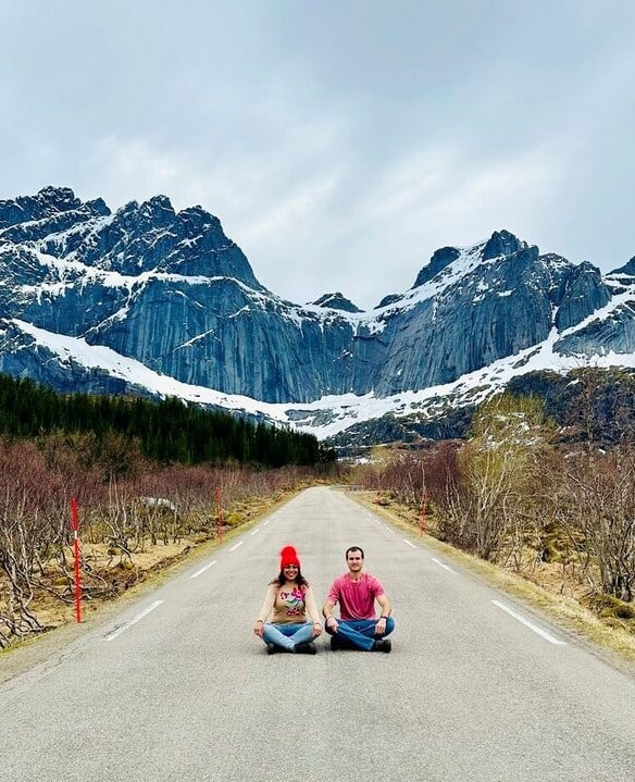
11) The Road to Nusfjord
As you drive to Nusfjord you’ll pass a straightaway in the road that looks like you’re driving straight into a cliff. This semicircular mountain rises high above a little lake below and provides an awesome backdrop to photos taken from the middle of the road.
There are a few places to pull over on the side of the road, just make sure you are not blocking traffic. The road is not busy, as it is not the E10 highway. It solely goes to Nusfjord and gets a fraction of the traffic.
For the best photos, stand in the middle of the road and take the photo from street level. If you have a tripod you can set it up. The road is long and straight and you’ll see cars coming from a distance.
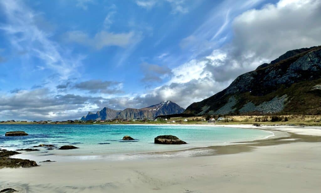
12) The Mannen Peak at Haukland Beach

The Lofoten Islands are full of super steep but rewarding hikes, and one of those takes you to the top of Mannen Peak. The mountain looks down on Haukland Beach, arguably the most beautiful beach in the Lofoten Islands.
From the top of the mountain, you get an incredible view of not just the white sand beach below, but the entire region of jagged peaks and stunning shorelines. For hikes in Lofoten, it’s tough to beat Mannen hike!
The total distance of the hike is only about 1.3 miles (2km) each way. But don’t be fooled, it’s straight up a mountain and will take about an hour for a normal person, less if you’re in really good shape. Parking is at Haukland Beach and you shouldn’t have trouble finding a spot.
There are amazing views throughout the hike to the top, but the best view really is from the peak. From here you get a 360 degree view of the west coast of the Lofoten Islands. The hike to Mannen is not to be missed!
13) Ryten Peak at Kvalvika Beach
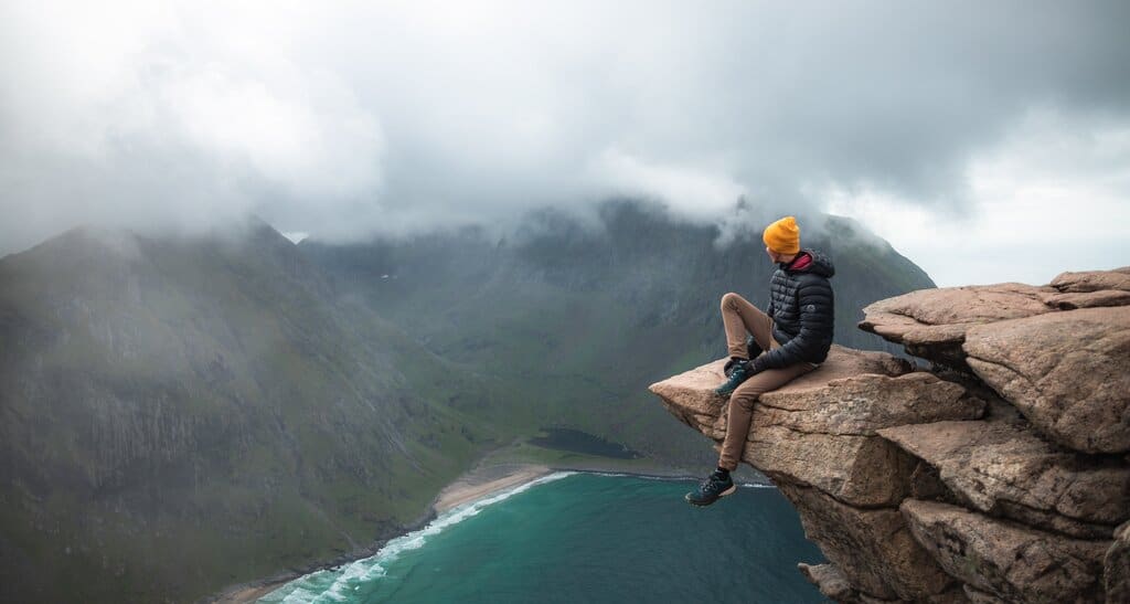
Another incredible hike on the west coast of the Lofoten Islands is the hike to Ryten Peak at Kvalvika Beach. This hike is similar to the Mannen Peak hike, but features one key difference on top of being about 500 ft higher in elevation gain. The beach below is not accessible by car, only by foot.
You have a few different options for where to start your hike. Both are about the same distance to the top round trip – 5 miles or so – and it really just depends on where you want to park. Many hikers add on the trail to the beach to their hike, which adds another mile or so.
The Ryten peak is specially known for a rock that juts out, allowing you the chance to take a photo that will convince your friends that you’re overlooking the abyss. In reality the ground is not far below the rock, but the photos can fool you.
14) Rambergstrands (Ramberg Beach)
One of the most beautiful beaches in all of Europe is Ramberg Beach on the west coast of the Lofoten Islands. The beach is a large cove that features white sand and stunning turquoise water. Any photo of Ramberg Beach will leave all your friends super jealous. Just don’t tell them how cold the water was!
Ramberg Beach has a number of accommodation options and there are a few places you can stay right on the beach, like Ramberg Gjestegard. For the best photos, stand at the far end of the beach and shoot back towards the inland mountains, which make for a gorgeous background for your beach photos.
15) The Bridge to Ballstad
Ballstad is a small town on the eastern coast of the Lofoten Islands that features sharp mountain peaks to the west. The town is surrounded by water and has numerous cozy accommodation options with spectacular views.
But the best view in all of Ballstad is from the bridge that connects the town – which lies on its own small island – to the rest of the Lofoten Islands. From here you can see colorful rorbus with imposing peaks in the background. It’s a photo to remember for sure.
Park off the main road on one of the side roads. There are plenty of spots. There is a sidewalk on the bridge so you shouldn’t have any issues getting the photo below!
16) The Stockfish Racks at Lofoten Seafood Center
We have discussed stockfish in this article already, so we won’t go over it again. If you’re in or near Leknes, there are some stockfish racks at Lofoten Seafood Center that have awesome views of the mountains in the background.
Lofoten Seafood Center farms salmon as well as catches wild cod. They run their whole operations out of the tiny village of Mortsund. It’s really not even a village, more of a road with a few houses. That adds to the allure.
If you’re not there during stockfish season (Jan – early June) then it’s probably not worth stopping by. Though the local rorbu is gorgeous and it’s neat to learn about stockfish and salmon farming at Lofoten Seafood Company.
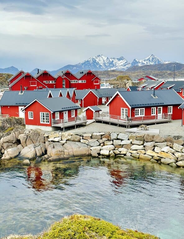
17) Statles Rorbusenter, Mortsund
Speaking of the rorbu near Lofoten Seafood Center, there are amazing photo ops near Statles Rorbusenter, the rorbu next door. In a land full of photogenic rorbus, this might be the best.
Statles Rorbusenter is huge, and there are cabins everywhere. There is a mountain behind the rorbu and if you climb up there you’ll get the best views of the little red cabins.
Any view of the rorbus is beautiful, so walk around and find your favorite angles!
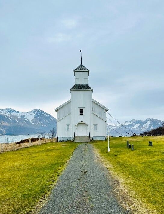
18) Gimsoy Kirke, Gimsoy
If you’re a fan of lone churches in the middle of nowhere, then Gimsoy Kirke is for you. The white chapel sits along the coast in an underpopulated and unvisited part of the Lofoten Islands. This makes it the perfect backdrop for mystic photos.
It’s not hard to get to the church. You just have to drive about 15 minutes off the E10 highway on a mostly one-way road and it’s on the right. The church itself is not open, but you’ll likely be the only one there so your photos will be pretty amazing nonetheless.
19) The E10, near Morpheus Beach
Along the E10 as you drive from Leknes towards Reine, you’ll pass a shallow inlet of crystal clear water. On each side of the water, the mountains shoot up towards the clouds. At the base of the mountains, a few lone cabins stand as a relic to the past.
It’s one of the most classic Lofoten Islands views and all you need to do is stop on the side of the road and step down a few rocks to the little beach below. There is not much room to pull over so be sure to use the exact spot linked here on Google Maps.
Lofoten Islands Photo Ops – FAQs
What is the most scenic place in Lofoten?
Picking the most scenic place in the Lofoten Islands is a tall order. Everywhere is just so stunning. But if you polled visitors they’d probably say the top of Reinebringen mountain. It’s totally worth the steep hike!
What is the best month to visit the Lofoten Islands?
The best month to visit the Lofoten Islands is July. This gives you 24 hours of daylight and the best chances to have favorable weather. It’s also the busiest time of year, however, so keep that in mind.
Why are the Lofoten Islands famous?
The Lofoten Islands are famous for quite a few things, including:
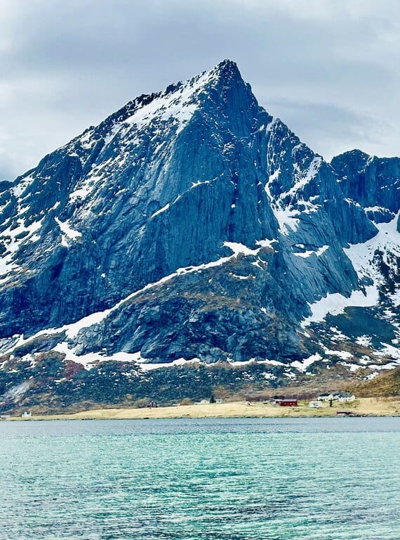
-Incredibly steep mountains that come right out of the sea
-Turquoise water and white sand beaches
-Adorable fishing villages
-Stockfish
-Being one of the most accessible places to see the midnight sun or the northern lights
Are there polar bears in Lofoten?
There are no polar bears in the Lofoten Islands. There are no bears at all. The only imposing lane creature you might see is moose.
If you want to see polar bears, you’ll have to hop on a flight up to Svalbard, a chain of Norwegian islands that holds the furthest north town in the world. And hundreds of blood-thirsty polar bears!
Final Word
In this article we’ve discussed the most Instagrammable places in the Lofoten Islands. This chain of islands may hold the most beautiful places in all of Norway, and it’s a photographer’s dream.
If you hit all the spots on this list you’ll be the envy of all your friends and family!